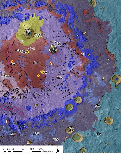
How can a geologic map of a lunar impact crater created billions of years ago help future human and robotic missions to the lunar surface? This is what a recent study published in The Planetary Science Journal hopes to address as an international team of researchers produced arguably the most in-depth, comprehensive, and highest resolution geologic maps of Orientale basin, which is one of the largest and oldest geologic structures on the Moon. This study has the potential to help scientists, engineers, and mission planners develop sample return missions that could place absolute ages on the Moon’s geology, resulting in better understanding the formation and evolution of our Moon and the Earth.
For the study, the researchers created a 1:200,000-scale geologic map of the Moon’s Orientale basin while focusing on identifying what are known as impact melt deposits, which are molten rocks created from a high-speed impact and intense heat that cooled and is now frozen in time, thus preserving its geologic record of when it was formed billions of years ago. The 1:200,000-scale means the map is 200,000 times smaller than in real life. Additionally, one pixel on the geologic map is equal to 100 meters, or approximately the size of an American gridiron football field, which improves upon previous Orientale basin geologic maps that were created at 1:5,000,000-scale.
“We chose to map Oriental basin because it’s simultaneously old and young,” said Dr. Kirby Runyon, who is a Research Scientist at the Planetary Science Institute and lead author of the study. “We think it’s about 3.8 billion years old, which is young enough to still have its impact melt freshly exposed at the surface, yet old enough to have accumulated large impact craters on top of it as well, complicating the picture. We chose to map Orientale to test melt-identification strategies for older, more degraded impact basins whose ages we’d like to know.”
The goal of the study is to not only create an improved geologic map of Orientale basin, but to provide a foundation for future missions to potentially obtain surface samples of the impact melt and return them to Earth for analysis. Such analyses would reveal absolute ages of the impact melt through radiometric dating since these samples have been frozen in time for potentially billions of years. These results could help scientists unravel the Earth’s impact history, as both the Earth and Moon were potentially formed around the same period.
Along with the targeted impact melt, the team successfully identified and mapped a myriad of geologic features within Orientale basin as part of the new geologic map, including smaller craters within Orientale, fractures, fault lines, calderas, crater ejecta, and mare (volcanic basalt deposits), while also constructing a top-to-bottom map of Orientale basin, also called a stratigraphic map, that shows the most recent layers on top with the oldest layers on the bottom.

Unlike Earth, whose surface processes like plate tectonics and multitude of weather processes have erased impacts from billions of years ago, the preserved lunar geologic record could provide incredible insight into not only Earth’s impact history, but both how and when life first emerged on our planet. This is due to Orientale basin’s crater size and age, as such a large impact on Earth billions of years ago could have postponed or reset how and when life first emerged on the Earth.
“Giant impacts – like the one that formed Orientale – can vaporize an ocean and kill any life that had already started,” said Dr. Runyon. “Some recent modeling has shown that we probably never totally sterilized Earth during these big impacts, but we don’t know for sure. At some point our oceans could have been vaporized from impacts, then recondensed and rained out repeatedly. If that happened a number of times, it’s only after the last time that life could have gotten a foothold.”
While Orientale basin is one of the most striking features on the lunar surface, more than approximately 75 percent of it is not visible from Earth due to its location at the lunar nearside and farside boundary on the western limb of the Moon as observed from the Earth. Therefore, studying the Orientale basin is only possible with spacecraft. Despite this, Orientale basin was first suggested to be an impact crater during the 1960s when scientists at the University of Arizona’s Lunar and Planetary Laboratory used groundbreaking techniques to “image” the sides of the Moon not visible to Earth using telescopic images taken from the Earth.
While NASA is focused on returning astronauts to the lunar surface with its Artemis program with the goal of establishing a permanent human presence on the Moon, returning scientific samples from Orientale basin could provide enormous scientific benefits for helping us better understand both the age of the Moon but also how and when life emerged on Earth billions of years ago.
How will the Orientale basin geologic map help us better understand the Moon’s and Earth’s history in the coming years and decades? Only time will tell, and this is why we science!
As always, keep doing science & keep looking up!


